
CYCLONE YASI APPROACHES AUSTRALIA â live coverage

• Cyclone Yasi, predicted to be the largest tropical storm ever to hit Australia, has struck the north-east coast of the country.
• The cyclone came ashore at around midnight local time (2pm GMT). Reports suggest houses have been damaged in towns and cities in Queensland.
• With elecricity out in many parts of the north-east, there will now be an anxious wait for daylight to reveal the extent of the damage.
• In Cassowary Coast, Queensland, councillor Ross Sorbello said Cyclone Yasi was stronger than Cyclone Larry, which hit Australia in 2006, causing nearly A$1bn of damage.
Minutes ago the eye of the storm arrived, the wind dropped and Mission Beach was eerily still. Stepping out onto the veranda and looking up, the stars were bright and clear. As the minutes ticked by and we checked for damage outside it was ... as if a blanket was being pulled across the sky, the stars were blotted out again by the cyclone thundering further across the coast at Mission Beach. The breeze picked up, and now we are well and truly back under the awesome power of cyclone Yasi. Winds are howling by at just under 300km per hour. The house is shaking and a tree has just hit the veranda but all holding up fine. A few more hours of this and then we'll see what the dawn brings...
and:
During the eye of Cyclone Yasi calls and texts were coming in thick and fast from friends and neighbours reporting damage and checking how everyone was shaping up. Reports of roofs off, sheds gone, trees down, power poles over and one friend with only about a quarter of their house still standing came through ... thankfully no reports yet on the grapevine of any injuries. We are all battened down in a very sturdy house, 9 adults, 4 teenagers, 3 children, 2 dogs, 1 cat and 3 fish...
Cassowary Coast Councillor Ross Sorbello said Cyclone Larry was a mere "boy" compared to Cyclone Yasi with roofs torn from houses and power poles knocked over.
The Townsville Bulletin in Queensland quoted the AAP report in its Yasi coverage:
Sorbello said the roof had been torn from his mother's house, where he was waiting out the storm, and local properties had suffered similar damage.
"We are talking about a pretty strong brick house that was built in the 70s, so god help us in the morning when we look at some of the older places,'' he told AAP.
Sorbello ventured outside briefly during the eye of the storm to access the damage and said the streets were strewn with debris while power poles had been knocked over.
"It is just a scene of mass devastation,'' he said.
"[Cyclone] Larry was a boy compared to this.''
He said the eye was yet to finishing passing over the town, meaning more damage was on its way as the winds ramped up again.
.
Attie says she went out in the eye of the storm, as did neighbours, and reports that electricity lines were down in Mission Beach, along with guttering from some roofs and bits of debris.
This animation from the US national oceanic and atmospheric administration provides a similar viewpoint.
THE LARGE DESTRUCTIVE CORE OF CYCLONE YASI IS STARTING TO CROSS THE COAST BETWEEN INNISFAIL AND CARDWELL, WITH A DANGEROUS STORM TIDE AND BATTERING WAVES TO THE SOUTH OF THE CYCLONE CENTRE.
Tropical Cyclone Yasi, CATEGORY 5, will continue to move inland in a west-southwesterly direction towards the Georgetown area during the morning.
As the cyclone crosses the coast, an EXTREMELY DANGEROUS SEA LEVEL RISE [i.e. storm tide] will occur between Innisfail and Ayr, peaking between Mission Beach and Lucinda.
Higher than normal tides exceeding the high water mark, and damaging waves will continue between Cairns and Proserpine until at least the morning high tide.
VERY DESTRUCTIVE winds with gusts up to 290 km/h between Cairns and Ingham and the adjacent ranges will extend inland and gradually weaken.
The VERY DESTRUCTIVE CORE of the cyclone will take up to 4 hours to pass.
DESTRUCTIVE winds with gusts in excess of 125 km/h between Cape Tribulation and Ayr will spread inland overnight.
Dozens of other cities and towns are being whipped by winds that the forecaster said could gust up to 186 mph (300 kph).
This live stream of the cyclone in Townsville shows the wind lashing palm trees. Apparently you can hear green tree frogs in the background.

The cyclone has struck land on Mission Beach, 50km south of the town of Innisfail, at midnight - just as meteorologists said it would. One resident of Mission Beach - sheltering in a concrete house - reports an extraordinary howling wind and large trees being uprooted.

Immediate attention should be upon those in danger from Yasi. But a big question in the aftermath will be whether the battering Australia has taken from extreme weather, on top of its recent long drought, will shift the country's stubborn streak of sceptical opinion on climate change. Climate sceptics, as elsewhere, are firmly in the minority, but their viewpoint appears to have become more popular in recent years.
Following the recent general election - seen by some as the world's first climate change election - cyclone Yasi could be a tipping point for opinion, suggest observers.
At 2pm on Wednesday, the wind changed from its usual tropical laziness into something purposeful and strong. The pressure also changed and the colour of the sky and sea transformed from metallic grey to a dust-red hue.
I leant my bike against a pylon on a pier in the middle of the Strand – Townsville's most famous beachfront attraction – and the first front of category five topical cyclone Yasi immediately threatened to blow it away.
With the wind came noise: one moment like a whistle or a hum, the next like traffic on an expressway. I cycled back through the tourist strip of the city, the launch point for visitors normally in search of coral or rainforest.
Townsville, with a population of about 180,000 people, is often called Queensland's northern capital yet everything was closed and boarded up. A sign graffitied on to plywood sheeting said: "Good Luck North Queensland." Residents and visitors were already sheltering in their homes and evacuation centres.
Two hours later, I cycled once more into the city and rode along the beachfront, having to be careful not be blown over by gusts or hit by falling branches. This time the seas had risen and debris was littered across the roads and walkways. It was no longer safe to be outside and I headed to our 70-year old home to join my wife and daughters.
In the days leading up to the storm, we were told by a builder that our roof would not survive the cyclone. But we were confident we could shelter safely underneath, and prepared food, water, tarpaulins and other supplies to get us through.
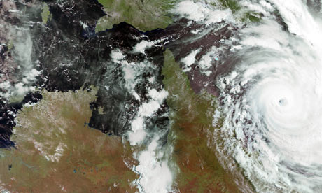
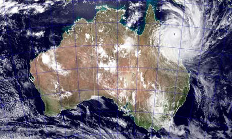 NASA image shows tropical cyclone Yasi as it approaches Queensland, Australia Photograph: Jeff Schmaltz/AP
News.com.au has a series of visualizations of how Yasi would look in different parts of the world which give an idea of the huge scale of the storm.
Yasi would completely engulf Britain and indeed most of the rest of Europe, or take up the majority of the US.

Tropical cyclones (also known as hurricanes or typhoons in other parts of the world) start off as low-pressure weather systems that form over warm water and have sustained winds more than 63kph near their centre. These gale-force winds can reach out to hundreds of kilometres from the centre of the cyclone and, if the winds get to more than 118kph at the centre, they are upgraded to "severe". The storm gets its energy from oceans where the surface temperature is more than 26.5C.
Jonathan Nott of the Australasian Palaeohazards Research Unit at James Cook University said Yasi looked like it would be the most intense and largest cyclone in the area since 1918. "In that year we had two very intense systems cross the Queensland coast, one through Innisfail and one through Mackay. We haven't had anything comparable since then until Yasi. It's a serious event. It's the biggest one that anyone living today has seen in Queensland."
He said a major problem was Yasi's large diameter. "We commonly get 'midgets' in Queensland – small diameter but still intense tropical cyclones. From time to time we get one of these very, very large ones but the midgets have been more common in recent years. It makes it more unusual for us again to see a large diameter system here," he said. "It's going to cause storm tides to go through people's houses. We can expect some areas to be really badly impacted by the storm tide. Larry didn't come through at high tide; it came through on a lower tide. It wasn't as intense as this system and it wasn't as large either. It didn't get any storm tide into houses but this one most certainly will. I think it will show people just how dangerous it is to live so low relative to sea level and so close to the beach."
Free video chat by Ustream Turn off live updates to watch in full
It's getting pretty wild.
The Queensland premier Anna Bligh - an impressive politician who won many new friends with her sincerity and compassion during the devastating floods - has told a press conference that Yasi has slowed down from 35km/h to 25km/h. The good news? A slower cyclone reduces the risk of flooding. The bad? It means the fierce winds will linger for longer, and are more likely to have a hugely damaging effect.
With the cyclone still two hours off the Queensland coast, 61,000 homes are already without power in the region, and the highest wave heights since records began have been logged just off the coast. A wave height of 9.5m has been recorded off Townsville - up by 2.5m since the afternoon.
There are now 89,000 houses without power in Queensland because of Yasi - more than half in Townsville. This means that even the evacuation centres will be without power. Townsville resident James Woodford says it is exceedingly dark outside. "It's windy and rainy and there is a lot of fear - not so much for us but all those Townsville residents who know that their houses are in the zone predicted to be affected by the flooding but not being able to know what is happening because it is so dark and horrible outside," he says.
A wave buoy off Townsville has recorded a wave of 18m but this is not accurate - Anna Bligh, the Queensland premier, said it was because waves are now breaking over the recording device, creating false readings.
Queensland state premier Anna Bligh said:
Tonight we need to brace ourselves for what we might find when we wake up tomorrow morning. Without doubt, we are set to encounter scenes of devastation and heartbreak on an unprecedented scale. This cyclone is like nothing else we've dealt with before as a nation.
Prime minister Julia Gillard has put 4,000 soldiers based in the garrison town of Townsville on standby to help once the cyclone passes, as well as military ships and helicopters.
What can parents do to alleviate the terror for children facing Cyclone Yasi? On television in Australia earlier today, newsreaders were recommending that parents prepare iPods and MP3 players with music or stories so that children would have something to listen to. Those who were children when the devastating Cyclone Tracy struck in 1974 still vividly remember the terrible sounds of the storm - the noise is particularly traumatic.
In Townsville, James Woodford, the author of a new book, The Great Barrier Reef, and his wife, Pru, says his daughters were actually a bit too excited about the impending cyclone. He showed his 10-year-old daughter, Sophie, some footage of Cyclone Althea, which struck the region in 1971, just to show her how dangerous a cyclone could be.
It is 10pm now in Townsville and James' daughters are asleep. He and Pru face a long night, however - they will stay awake in case they need to take their children to shelter underneath their house. The family only moved into their historic "Queenslander" house a few months ago; while they re-screwed their roof down they are worried the cyclone will lift it off. If that happens, they will seek shelter between brick walls underneath their home, which is built on 1.7m high posts. Being 7m above sea level, the Woodfords hope they will avoid the furthest reach of any storm surge from the ocean. "This is a 70-year-old house and it has survived a few cyclones so maybe there is something in that," says James.
"Do not bother to pack bags. Grab each other, and get to a place of safety," says Anna Bligh, Queensland state premier.
I've just spoken to Louise St George, 30, an events manager from Cairns who is now holed up in the Holiday Inn in the city. This building is right on the esplanade so it doesn't sound like the most logical place to be but it is actually built to withstand a Category 5 cyclone. As we spoke, sirens sounded and Louise and her partner, Andrew, retreated to a bathroom on the 4th floor of the building. This will be high enough to avoid the predicted eight metre storm surge from the ocean. People are also advised to choose the smallest room - hence the bathroom. "The waiting is very scary. It's going to be pretty intense," she says, describing the calm before the storm as a creepy kind of feeling. She has been told to expect to sit tight for up to 20 hours, waiting for Yasi to pass.
Queensland is expected to bear the brunt of the cyclone, with about 400,000 people living in the storm's path, which is expected to take in the cities of Cairns, Townsville and Mackay.
Yasi has been designated a category five tropical storm, the highest ranking available. It is expected to reach the Australian coast within the next few hours, its arrival potentially coinciding with high tide – adding to flooding worries.
The Australian Bureau of Meteorology has issued 11 weather warnings in the state, and its website bears this statement on the severity of Cyclone Yasi:
THE VERY DESTRUCTIVE CORE OF CYCLONE YASI WILL CROSS THE COAST NEAR INNISFAIL CLOSE TO MIDNIGHT, WITH A DANGEROUS STORM TIDE AND BATTERING WAVES SOUTH OF THE CYCLONE CENTRE.
Tropical Cyclone Yasi, CATEGORY 5, will continue to move in a west-southwesterly direction and is expected to cross the coast near Innisfail close to midnight.
Coastal residents between Cairns and Ayr are specifically warned of an EXTREMELY DANGEROUS SEA LEVEL RISE [i.e. storm tide] as the cyclone approaches, crosses the coast and moves inland.
Higher than normal tides will exceed the high water mark with damaging waves and flooding in low lying areas in remaining warning areas to the south of Ayr.
VERY DESTRUCTIVE winds with gusts up to 290 km/h are expected to develop between Cairns and Ingham during the next few hours as the cyclone approaches. These VERY DESTRUCTIVE winds will extend inland to the nearby ranges including the Atherton Tablelands.
Due to the large size of the cyclone, people in the path of the VERY DESTRUCTIVE WINDS are likely to experience these conditions for about 3 to 4 hours.
DESTRUCTIVE winds with gusts in excess of 125 km/h between Cape Tribulation and Ayr are expected to spread inland overnight.
Follow the latest news on the cyclone here.
VIEW VIDEOS
http://www.guardian.co.uk/world/blog/2011/feb/02/cyclone-yasi-australia-live-coverage